

 |
 |
 |
 |
 |
 |
 |
 |
 |
 |
| � |

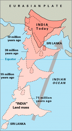
About 160 million years ago the different continents splitted from the two major continents and formed some of the present continents. After that about 65 million years from today India separated from Africa and started heading southward a few hundred kilometers. After that it took itself straight northward toward the present countries Pakistan, China, Nepal. Later about 45 million years from today the formation of the Himalayas began while the Indian Plate collided with the Eurasian Plate at the rate of 15 cm per year. The stress was great between the plates which caused earthquakes of high magnitude. Indian Plate is still moving northward today into the Eurasian Plate at the rate of about 2 cm per year. Because of this the Himalayas are rising at the rate of about 5 millimeter per year. This means that the Himalayas are still geologically active. For this reason, earthquakes are a frequent occurrence in the entire Himalayan region. Earthquakes from 2-8 on the richter scale have been recorded.
The Himalayas are known to be young mountains. These mountains were formed relatively recently in the earth's history. Himalayas are younger than Appalachian in the United States. We could tell this by observing that amount being eroded every year.
| ALFRED WEGENER (1880-1930) Alfred Wegener was born in Berlin, Germany. He was the first person to propose this theory of continental drift in 1912. He used to fit together the continents, and he used to match the fossils, rock profile, glaciers. At first people didn't believe his theory. Afterwards in the 50's his theory got famous. |
This earthquake struck in the early afternoon of January 18, 1975. It caused disasters in parts of the Kinnaur, Lahaul and Spiti regions of India. Seismographers think that the movements along the Kaurik Fault caused this earthquake to occur which killed hundreds of people and cause severe damage of property.
Two massive landslides took place during the earthquake. One of them was near Maling in the Spiti Valley. The other one blocked the Paro chu River near Sumdo. Many smaller occurrences of slope failure wre cuased by this earthquake. Communications failed and helicopters were used to bring relief. The magnitude of this earthquake was about 7.8 on the Richter Scale.
Dharchula Earthquake
This earthquake struck Dharchula and the surrouding areas of Pithoragarh District in the Kumaon Himalayas. Thsi Earthquake took place in December 1980. Displacement along the fault is thought to cause the earthquake which affected the parts of the inner dry valleys of Pithoragarh District. The magnitude of this earthquake was about 8 on the Richter Scale
Uttarkashi Earthquake
This earthquake took place in the early morning of October 14, 1991. This earthquake was so severe that it shook most parts of Uttarkashi and Chamoli districts of Garhwal. This earthquake was very severe and caused a lot of lives and property damage. The communication was destroyed and the region was cut off from the rest of the world due to the debris. Landslides also occured at many locations. The magnitude of the earthquake was about 7.9 on the Richter Scale.